 orecast
 Play video
Clicking loads the video from YouTube. Nothing is loaded from YouTube or Google before that.
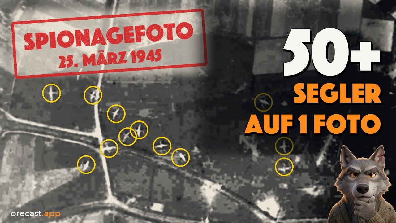
At first glance the photo shows nothing but fields, hedges and a few lanes on the Lower Rhine. An American reconnaissance aircraft took it over Hamminkeln on 25 March 1945, pointing straight down, at a scale of one to twelve thousand five hundred. Look closer and you see small pale crosses on the fields, some with a long track behind them. They are not trees or haystacks. They are aircraft without engines, military gliders, and this single picture shows more than fifty of them.
53,224 photos and one cluster
In the spring of 1945 the Allies flew over Germany almost every day and photographed it from above. A single frame covered a strip of land up to three kilometres wide. Photo interpreters searched the images for anti-aircraft positions, bridges, railway lines and craters. Hundreds of thousands of these pictures are held today by the US National Archives, and because they were made by a US federal agency they are in the public domain.
At orecast we have collected 53,224 of these photos over Germany and placed them on the map by location and date. Around 38,000 of them date from the last year of the war. Most show landscapes where nothing seems to happen. On some days, however, the pictures pile up in one place. Around 23 and 25 March 1945 that place is Wesel. The Wesel and Hamminkeln area alone has 169 photos, 27 of them from 23 March and 53 from 25 March.
How we went about it
First we sorted all photos by place and date and looked for such clusters. Then we laid the pictures of a cluster side by side and searched for shapes that do not belong in a landscape: crater fields, smoke, crosses on farmland. Finally we added the relief, a laser scan of the ground that shows, even beneath trees, whether a trace in the terrain still survives.
Not every trace leads somewhere. Near Velbert, south of Essen, Krupp had a decoy factory built from wood, cardboard and lights during the war, so that bombers would drop their loads there instead of on the real works. According to a local source, seventy high-explosive bombs and mines and more than five thousand incendiaries fell on the Rottberg hill. We searched more than a hundred square kilometres of relief for craters. Around the old bunker they are no denser than in the surrounding area. The fields were levelled long ago. This empty result belongs in the episode too.
What the photos show
On 23 March 1945 the pictures show the area around Wesel covered in pale spots. Each one is a bomb crater, along the Lippe, at Pavershof, on the Büderich island. Two days later the land to the north looks different. On the fields near Hamminkeln lie crosses with tracks behind them, some broken, some lying askew in a ditch. Smoke drifts across the fields.
These crosses are gliders. A transport plane tows a glider on a rope to the target, where it releases and glides to the ground. It carries soldiers, or jeeps, guns and ammunition. It can land only once.
24 March 1945: Operation Varsity
On the evening of 23 March the Allies crossed the Rhine at Wesel and Bislich. On the morning of 24 March the largest airborne operation of the Second World War began: Operation Varsity. Shortly before ten o'clock the first paratroopers jumped, followed by around 1,300 gliders. The sources give slightly different figures, so we stay with "around". Near Hamminkeln the British 6th Airlanding Brigade came down on several fields, landing zones O, U, R and P. Its objectives were the town and three bridges over the river Issel. The German flak had survived the preceding artillery barrage and fired into the slow, low streams of gliders.
Counting the photo
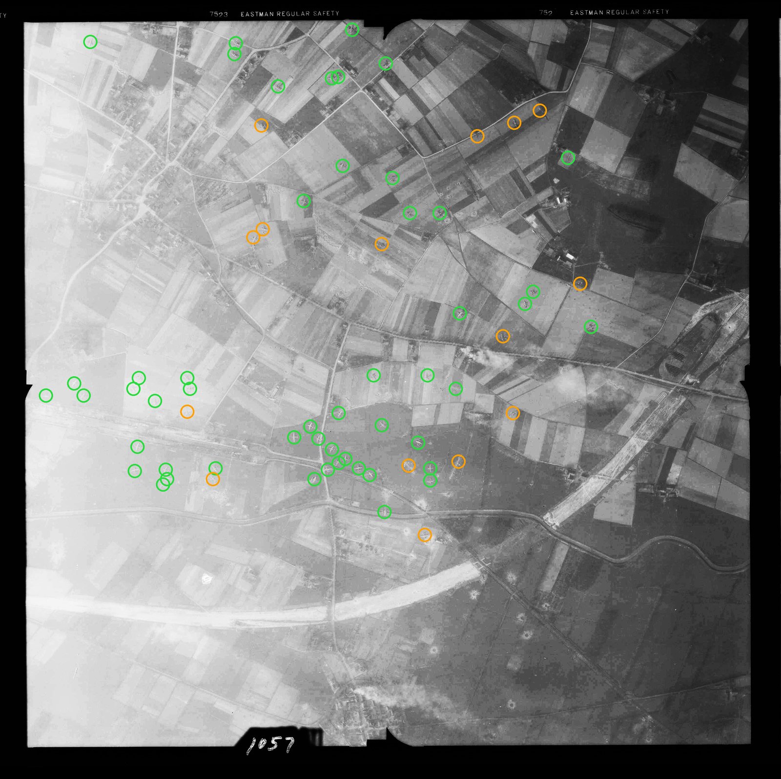
Our photo was taken one day after the landing. We divided it into nine sections and marked every cross, green for certain and orange for uncertain. 51 gliders can be identified with certainty, plus 15 that are too small or too blurred to be sure. On the negative a glider measures only a few millimetres; some lie in the shadow of a hedge, others are broken into pieces. The figure applies to this one picture. The neighbouring frames of the same run show further fields with further gliders. As far as we know, nobody has counted them across these photos before.
If you want to count along: the original is in the US National Archives catalogue, and our marked-up image is part of this post.
The people
For the people of Hamminkeln the day was an inferno. Eyewitnesses remember mortal fear and a noise they called the din of hell. The fighting lasted until the afternoon, with counterattacks until the next morning. The British 6th Airborne Division alone lost 347 men killed in this operation. Not a single person can be seen on the photos, yet behind every cross there were people. We have not verified the civilian casualties for this post, so we give no figure.
Hamminkeln today
We laid the 1945 photo roughly over today's aerial image. The old town centre is still there. Much of the farmland where the gliders came down has disappeared under halls, car parks and an industrial estate. In the relief hardly anything of the landing zones remains, because farmland is ploughed every year. What the fields have forgotten, only the photo still holds. On Güterstraße a memorial stone and a tree commemorate the landing.
Do not dig
Unexploded ordnance still lies in the ground around Wesel and Hamminkeln: shells, bombs and ammunition from those days. Anyone who finds something like that must not touch it and should call the police on 110. Digging and metal detecting in former battle areas are dangerous and forbidden in many places.
In the orecast map you can lay the aerial photos of 1944 and 1945 over your own town (with Pro). Perhaps you will see what was happening in your street eighty years ago. The scenes from the past in the video were created with AI and are labelled as reconstructions. The 1945 aerial photos, today's aerial image and the relief are real.
Illustrations generated with AI.
Frequently asked questions
What is a military glider?
An aircraft without an engine. A transport plane tows it on a rope to the target area, then it releases and glides to the ground. It carries soldiers or vehicles, guns and ammunition. It can land only once; there is no way back.
Where do the reconnaissance photos come from?
From Allied aerial reconnaissance. The images are held by the US National Archives (Record Group 373) and, as works of a US federal agency, are in the public domain. orecast has located 53,224 of these photos over Germany by place and date, around 38,000 of them from 1945.
Is it allowed to search or dig on the former landing zones?
No. Shells, bombs and ammunition still lie in the ground around Wesel and Hamminkeln. Anyone who finds something that looks like ammunition must not touch it and should call the police on 110. Digging in former battle areas is dangerous and forbidden in many places.