 orecast
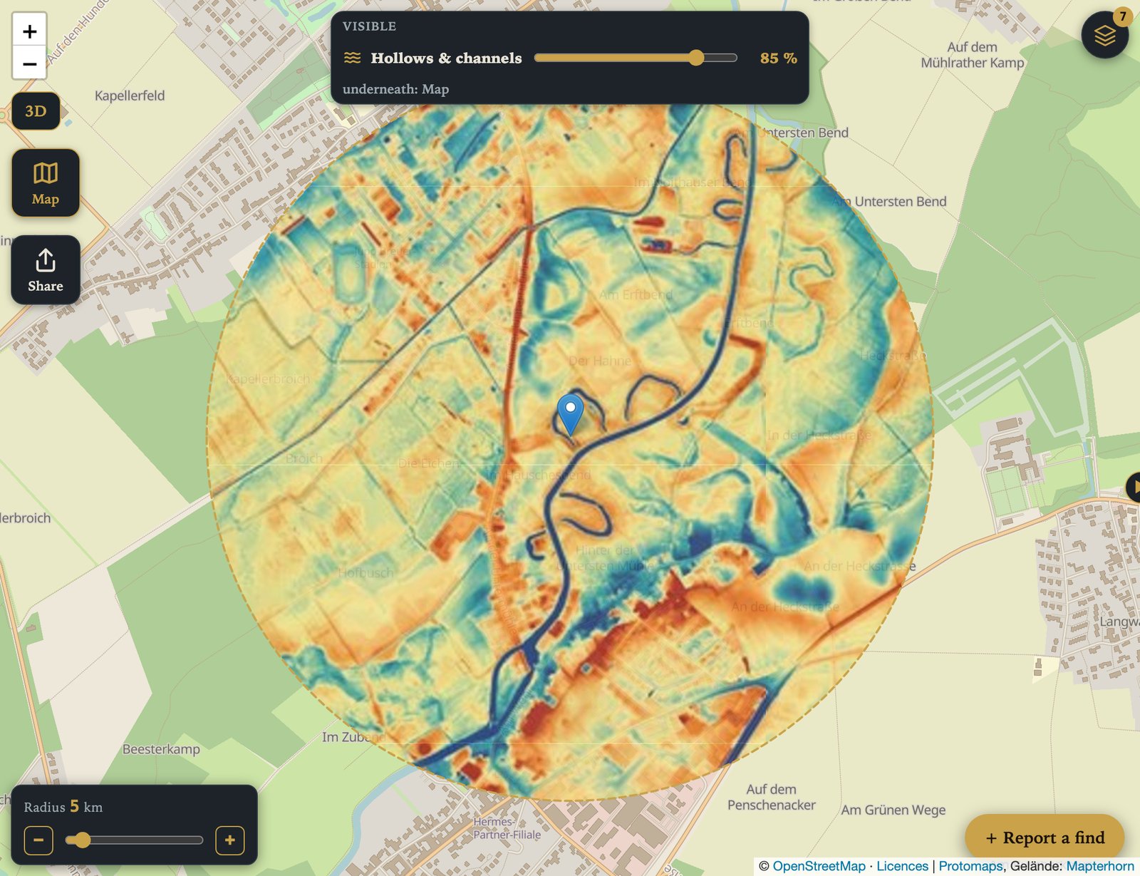
Anyone who has walked across a river floodplain knows the feeling: the meadow looks as flat as a table. Yet after rain, water stands in some places and not in others. The difference is often only 30 or 50 centimetres. You can barely see it with the naked eye and not at all in an aerial photo. That is exactly what the new hollows & channels layer in the orecast map is for.
What the layer shows
The layer compares every point with its surroundings within a few dozen metres. If it lies lower, it turns blue; if it lies higher, it turns red. Yellow means roughly level with its surroundings. This removes the large shape of the landscape, whether a place sits at 40 or 400 metres, and leaves the small shapes. In hilly country the colour scale adapts, so that a steep slope does not drown out everything else.
The relief scanner works differently. It lights the ground from the side like a low sun and so shows edges and banks. On flat floodplains, however, that shaded image stays almost plain grey, because there are hardly any edges. Hollows & channels shows the height itself, and it becomes colourful exactly where the relief has nothing left to show.
What you find better with it
- Silted up river loops. Old meanders that were filled in or overgrown long ago usually still lie a little lower than the floodplain. The picture above shows several of them along the Erft.
- Channels in the floodplain. Shallow flow paths that carry the water during floods.
- Ditches and embankments. Drainage ditches, dykes, railway embankments and old tracks stand out as fine blue or red lines.
- Terrain edges. The step between floodplain and higher terrace, where tracks and settlements often used to lie.
- Hollows and depressions. Dried up ponds, pools or old diggings in fields.
Important: the map shows landforms, not find spots. It says nothing about how old a form is or how it came about. Whether a blue loop is an old river arm, a ditch or a pit can only be settled by old maps and a visit on site.
How accurate is it?
The layer is calculated from a terrain model with a grid of about three metres. Before switching it on, we laid it against the official one metre models of the German states, on the Erft in North Rhine-Westphalia and on the Danube in Bavaria. Both times the heights matched almost exactly, and about 94 percent of the hollows lying more than 40 centimetres below their surroundings also showed up in our layer. Very narrow ditches one or two metres wide can still be missed; the relief scanner is sharper for those.
The layer covers all of Germany and Austria and large parts of Europe. The details are on our coverage map.
How to switch it on
In the web map, the layers button at the top right opens the map selection. Under "Add on top" you will find the line hollows & channels. The slider at the top sets how strongly the colours sit over the map, so river, roads and towns still show through. In the iPhone and Android apps the layer is in the map selection as well. Without a subscription there is a preview within one kilometre of the map centre, with orecast Pro the whole map.
Please do not dig
Many landforms are protected archaeological monuments. Digging or detecting there without a permit is prohibited. If you find something, leave it where it is and report it to the heritage authority, and report ammunition to the police straight away. Looking, understanding and hiking there are very welcome.
A good first look: the Erft near Grevenbroich. Switch on the layer and see where the river used to draw its loops.